
Advisor: Mr. Nicolò Doglioni, Geologist Project Description:
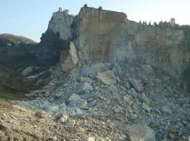
San Leo, the historical village close to San Marino Republic, lays on small flat area at the top of a relief surrounded by vertical faces 80-100 m high. In 2014 almost 350000 m3 of rock suddenly collapsed from the north west face; the upper crest line of the collapse slightly damaged some houses and a road at the top so that the villagers were forced to move out. The goal of the survey was defining the stability condition after the collapse, the risk for the village, and the remedial measures in the long and short terms. Several specialists were involved in order to supply radar monitoring of the rock mass movements, topographic survey with lidar technology, geological survey, geomechanical survey, stability analyses and risk evaluation.
Activities Performed:
Geo mechanical survey, stability analysis (limit equilibrium method)
Definition of the hazard, analysis of the special bore hole investigations.